The dotted lines on the map between Shintuya and Iberia, and Puerto Maldonado and Iberia, represent the two missing links, of which only one is needed, for the first TransAmazonic road link-up between Lima and Rio de Janeiro (according to Peruvian Times figures the distance along this route is roughly 4,895 km). A PERUVIAN TIMES Report published Dec. 5, 1969.
By Marion Morrison
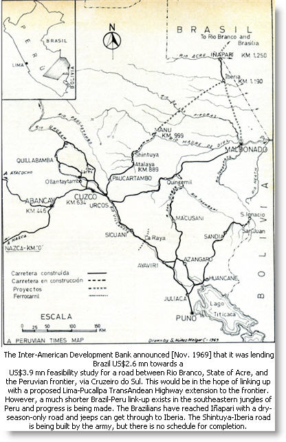 The road from Cuzco to the Atalaya settlement on the banks of the Alto Madre de Dios is approximately 212 kms long, crosses two ‘cumbres’ with the highest point at 13,000 ft, and then drops steeply to about 1,000 ft above sea level. The best known town on the route is Paucartambo and there are two ways of getting there from Cuzco: either through Pisac, which is not recommended, or by driving 25 kms south along the main Cuzco-Sicuani highway and then striking to the east just before Urcos. This branch road climbs slowly over the mountains, is reasonably wide and well graded, and passes through the barren puna before dropping to Paucartambo at approximately 9.000 ft. One-way traffic only is allowed on the road; from Cuzco to Atalaya on Monday, Wednesday and Friday and in the other direction Tuesday, Thursday and Saturday. On Sundays there is no control but the road becomes dangerously narrow and there are few places where trucks can pass. From Paucartambo, crossing the river of the same name, the road climbs again to the second ‘cumbre’ passing very close to the famous point of Tres Cruces where the Incas would sit at midwinter solstice to watch the sun rising above the jungle 10,000 ft below. (It’s still a good place for doing the same thing). In the final descent, the road twists endlessly through quickly changing vegetation but the surface is in excellent condition: graded and with little ‘calamina’, although in places the dampness of the surrounding cloud forest converts the dry surface into slippery mud.
Guard Post
A deep precipice falls away on one side with high cliffs of rock on the other. There are few stopping places, though a good meal can be bought at Buenos Aires, a small shack perched on a corner some three hours beyond Paucartambo. There is a guard post at Chontachaca, which strictly controls the traffic, not allowing any vehicle to start the uphill run until three in the morning, when it is estimated that all downhill traffic has already passed. A modern bridge crosses the River Cosnipata before the road reaches Atalaya where there is a Guardia Civil post which shuts around midnight. Only six kilometers from here is the military post of Salvacion, the headquarters of the Army Corps that has been building the extension of the road from Atalaya, and once again, all documents have to be shown and noted. This post is shut between midnight and seven in the morning. The new road, from Km 212 to Shintuya at Km 256, where “it ends,” is first class: about 30 ft wide, graded and well maintained; and as it traverses the vestiges of the Andean foothills, the slight gradients along the route present no problem because the road has been well designed. This section of the road, however, will only be in service during the dry months as it is crossed by four wide rivers and there are no bridges apart from a couple of small Bailey bridges across deep culverts. So colonists who have already begun to settle along the road and around the Shintuya mission have to revert to the old form of transport during the rainy season and have to travel to Atalaya by canoe.
Marion Morrison wrote this story just after filming, with photographer and author husband Tony Morrison, the first full-length documentary program on the Manu National Park —A Park in Peru— for the BBC.