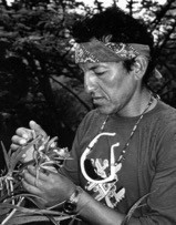
By Gary Ziegler ✐
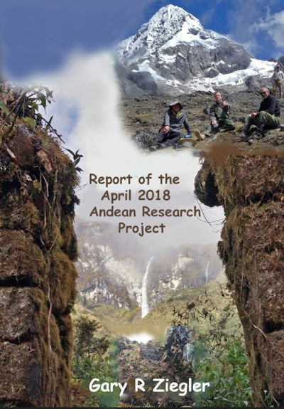
The Andean Research Expedition Report 2018 ☄
 “Steve, bail out!” I shouted. Horrified, I watched helplessly as the bay horse slid off of the narrow, muddy track, flipping upside down, legs flailing into the deep ichu grass-lined gully.
Steve Lasswell, team member and friend from home Colorado, managed an athletic tuck and roll, clearing the struggling horse as they landed together unharmed into dense polylepis growth below. Both were soon retrieved with some difficulty by machetes and ropes. We wisely decided it was time for a break.
“Steve, – you just qualified for an army airborne badge,” I quipped, as we popped open a couple of power bars.
The ancient, cloud forest, Inca trail we were following had not been cleared or used in decades. Deep groves and remains of old chopped trunks indicate that it had probably seen travel in past, post-Inca times by local herders but had long fallen out of use and memory. My Cusco-based research associate and expedition Maestre de Campo, Edwin Dueñas, along with our long time head wrangler, arriero, Pio Espinosa had previously scouted out the route last year on a planning reconnaissance.
They reported sightings of mountain top ruins and that we would be able to open and follow the old Inca route to get near there. We calculated that with extensive clearing help by a local crew from the nearby Santa Teresa Valley, we could then drop down to where we had terminated previous explorations in 2016 and access a road leading back to civilization.
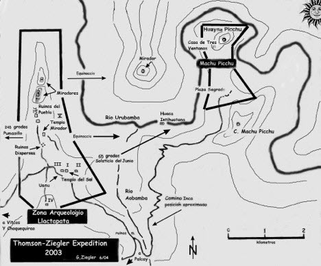
This is the latest in a series of annual exploratory expeditions which a small group of us have been undertaking since our rediscovery and survey of the what we called ‘Machu Picchu’s ceremonial neighbor,’ the extensive archaeological complex of Llactapata in 2003.
Located less than five kilometers distant and several hours travel time away from Machu Picchu during Inca occupation, Llactapata was a busy complex of separated, interconnected groups, ceremonial features huacas, temples, usnus, a water-focused sector and a large urban agricultural district supporting Pachacuti’s now tourist famous royal estate.
The exploration of the steep, dense, cloud-forest slopes; the subsequent locating and survey of lost ruins with discovery of the Inca trail connecting Machu Picchu’s Hanging Bridge during 2003-2004 is an interesting story. The original field report was published in Peru’s profession journal in Spanish. “Revista Andina #39, Malville, Thomson and Ziegler 2004.”
Archaeoastronomer, Kim Malville and I later published much of the report in our 2013, co-authored book:
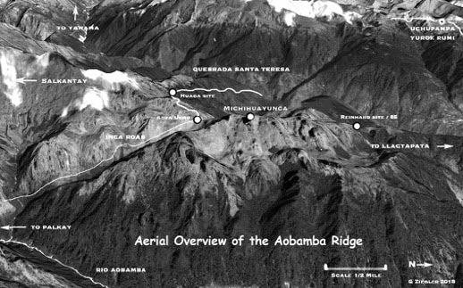
The Llactapata sites are located lower down on a long, multi-summited ridge running southward up to the glacier covered roof of 20,500 feet high Salkantay, the highest peak in the Vilcabamba range and sacred mountain apu for the Inca. The Machu Picchu complex is situated similarly on a parallel ridge separated from the Llactapata ridge by the deep Aobamba
River Canyon.
A steep, geologically unstable, mixture of fractured granite plutons, folded and faulted, down-trending metamorphic strata, unstable colluvium breakdown and high up, glacial moraine, creates a hostile and dangerous landscape. Recent catastrophic slides and flooding have tragically demonstrated this.
In the El Nino year, 1998, a massive flood was created by the damming of the Aobama Canyon by a huge ice slide breaking away from Salkantay. When the massive, backed up lake and debris eventually broke free, It plunged down to block and flood the Urubamba River and canyon below.
Hundreds were killed as the flooding swept away river-side towns, bridges and the railroad. The rails were never replaced, terminating the rail line at the Hydroelectric Plant, eleven kilometers below Machu Picchu.
I trekked through the devastated area several mouths later, penning a short story from an eye witness which I titled “The Last Train to Quillabamba.” Here is some of what I wrote at the time:
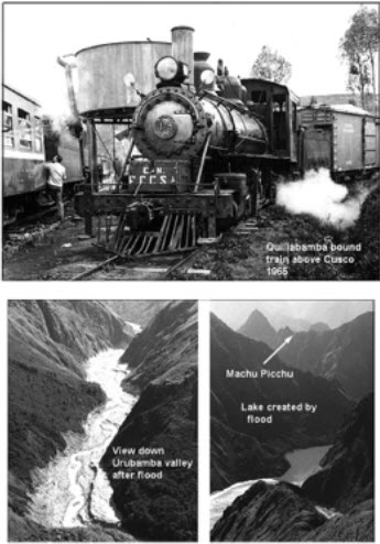 “Mule trails are wiped out and just now being reopened. The railroad to Quillabamba is gone from the hydroelectric plant on (so is the plant) about 10 kilometers below Machu Picchu. A tremendous flood came down the Quebrada Aobamba (next side canyon down river from Machu Picchu) damming up the Urubamba, filling the valley with a broad, long lake which covers the plant.
The railroad stops at the first switchback above the lake with the rails disappearing into the water. My photo taken from high above the canyon with Machu Picchu in the background looks like a Norway Fjord. Tourists and even most Cusco residents are unaware of this as it is not visible from Machu Picchu or the tourist trains that stop at Puente Ruinas well up river.
Accounts of personal hardships and tragedy are everywhere. An engine and several cars sit abandoned on a short section of rails terminated on either end by the river.
A woman told me an incredible story. She had just boarded the up train from Santa Teresa at 3:30 pm on February 27 on its way to Machu Picchu and Cusco when the train suddenly stopped in a torrential rain. The crew forced everyone off the train and up the steep canyon side. Moments later, the train was swept away never to be found.”
In 2006, we hiked down the massively eroded Aobama Canyon following what remained of an old Inca road.
Meanwhile, back to the present expedition:
April weather in the high Andes is never completely predictable. Intensity of the rainy season usually slacks by late March allowing reasonably comfortable, land slide free travel. Anomalies like El Nino contribute an uncertainty to an already uncertain science.
We were soon to experience some of the worst; fog, mist, rain and deep mud making trails treacherous and trying, arduous travel. Several camps were almost bivouacs chopped out on steep slopes at 14,000 feet or more. Comfortable dry tents, our Chef Pancho’s near gourmet meals, the evening ration of single malt libations helped make it all bearable. And of course, most important, was the successful achievement of our objectives.
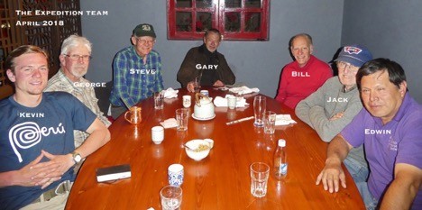
 Traditionally launching the expedition, seven of us, along with an old Friend, David Espejo, met for a traditional happy hour briefing at Cusco’s Norton’s Pub. David goes way back with me to the early Vilcabamba expeditions.
Getting through the needed logistics, David and I launched off on old stories of places, events and adventures we had shared, one of the best being an Australian feature length fantasy film; Lost City of Gold which we had starred together in. He played a coca leaf chewing, mystical Andean Shaman and I, a dour, Hiram Bingham like character.
Sadly, he could not join us on this one.
Quillarumiyoc; ‘place of the moon rock’
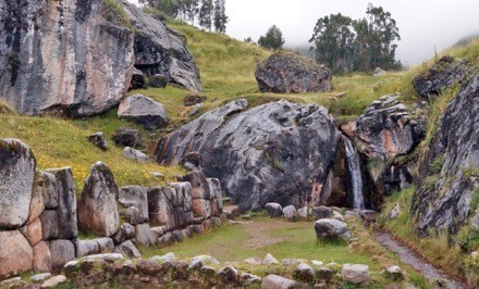 Early out on the road the next morning, we had time to visit Quillarumiyoc, one of my favorite Inca sites along the central highway heading westerly toward the Apurimac, . We previously had interpreted the extensive number of features to be a multi-ceremonial complex.
It is spread over several square kilometers on a gentle sloping hill side encompassing rounded hills and a lush wet valley. The geological structure is a gray limestone similar to much of the base rock of Cusco, soft, uniform in consistency and easily shaped.
Quillarumiyoc is a Disneyland of sacred landscape, objects, huacas, manipulation of water and geo-cosmic alignment. It seems to incorporate most of the important elements of traditional Andean spiritualism along with important solstice focus.
There is a cave with fine, inside masonry like the Cave of the Moon at Machu Picchu. There are numbers of large sculptured boulders like the White Rock at Vitcos, Yuroc Rumi which probably replicate the surrounding topography.
There is a channeled stream complete with a waterfall into a stone-lined pool.There are petroglyphs, carved seats that face the December solstice sunrise, the June solstice sunset and a stepped usnu platforms with paved walkways and steps.
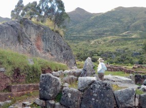 The pièce de résistance is a raised, filled, U shaped usnu platform enclosed by a carefully made retaining wall of imported square-shaped, reddish andesite blocks.
The open end of the U faces north, ending with a giant shaped boulder as the backdrop.
The centerpiece of the platform facing the boulder Is a tall, upright monolith carved in a traditional stepped motif which Kim Malville suggests is a symbolic stairway to Hanan Pacha, the world above.
Another unique feature is a stylized, half circle carved in the steep side of one of the large boulders large enough for two or more to sit in. A hole in the floor allows offertory fluids to flow out some distance below. The outward alignment is 110 degrees, facing the December solstice sunrise on the near horizon.
This is the best known feature, the reason for the name given to the site. Quilla means Moon in Quechua. Early visitors thought the carving represented the Moon.
We drove on to camp that afternoon near Lima Tambo. Tents were set up, gear sorted from the van and preparations made for horse mounted departure the next morning completed.
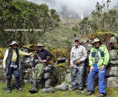
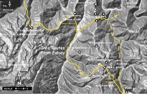
Palcay, Hiram Bingham’s Almost Lost City Revisited
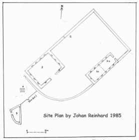
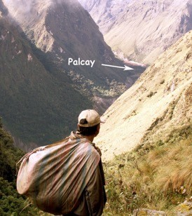 After crossing several high passes, we reached a previous campsite at Hiram Bingham’s remote site, Palcay two days later. During a break from work at Machu Picchu in 1912, Bingham visited and sketched a plan for this then undocumented site.
Located in a deep canyon near the upper limit of the Aobamba River, Palcay is extremely difficult to reach. Decades later in 1985, American anthropologist- mountaineer, Johan Reinhard visited Palcay. He described it and another now lost again Inca site located between Palcay and the upper reaches of the Llactapata archaeological zone. British archaeo-explorer, Hugh Thompson also explored the region in the1980s while working with British archaeologist, Ann Kindall’s Cusichaca project.
Our 2006 expedition reached Palcay after a long, difficult backpacking slog up from the Santa Teresa Valley to the West, I published a project report titled “Palcay, an Almost Lost City and Other Explorations: A report of the 2006 Andean Research Expedition, South American Explorer # 84, 2007.” An excerpt explaining our objective follows:
“Our immediate goal was to reach Palcay to survey and interpret the site. We hoped to visit two other small ruins reported by Reinhard and definitively locate the several Inca roads know to have passed through the region. We would look for other Inca or pre-Inca constructions to complete the reconnaissance. As the region is so difficult to access, we probably would not return again. We must give it our best shot.
Expeditioning in the Andes requires tremendous planning, time and funding. Each season, we are usually able to accomplish only one exploration, resulting in that we plan and choose very carefully where we explore each year. My own focus over the past several decades had been systematically investigating likely locations for Inca activity in the Vilcabamba which now receives a lower priority. Since our exciting 2003 discovery at Llactapata along with the realization that a complex design relationship of ceremonial sites surround and were associated with Machu Picchu, we have concentrated efforts to gather all the related data we can.
We hope to better understand what I call Machu Picchu’s geo-cosmic grid of shrines huacas, sacred mountains apus, celestial, and in particular, solstice-equinox alignments. Ongoing Llactapata-Machu Picchu studies strongly suggest that all the regional sites and the numerous viewing platforms, usnus are laid out by placement and design in planned relationship to each other, important terrain features and astronomical alignments. We were eager to see if, or how, Palcay and the high Aobamba sites would fit this model.”
So, here we are again some twelve years later. Unfortunately, none of the 2006 team could be with us. John Lievers was happily training a ladies rowing team in home Australia. John Martin, most recently with us on the October, 2016 project, had committed to a family journey to Easter Island. Paolo Greer was involved in other projects but as always was on email standby to send a collage of satellite images upon our return.
Our new team had two project veterans; Steve Lasswell, taking a break from being Mayor of Silver Cliff, Colorado and intrepid, expeditionary veteran, Quechua speaking, Jack Vetter who first signed on for the 2003 Llactapata investigations. Jack has made almost every annual exploration since. Three new, enthusiastic others rounded out the team along with Edwin, Pio, camp chef, Pancho and I.
 George Koons, a Colorado friend of Steve and I, is a skilled, fit, back country horseman and adventurer who we successfully talked into joining on. Bill Tollard, friend of Mark and Jim Johnson from Denver, members of the April, 2016 Research Expedition to Incaracay and Choquequirao signed on with their encouragement. Having poked around the remotes of Alaska, Bill was well prepared.
The third new member, Kevin Miller, is a young, educated, adventurer, eager to learn and carry on professional explorations in the remote Andes.
I suspect he may have accumulated more than enough experience with the mud, rain and the extremes we encountered. His ‘got to get up there’ attitude reminds me of a younger John Leivers forcing us to climb the highest, rocky knob summits at Llactapata or chop through where none dared go.
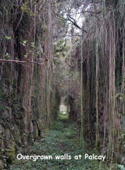
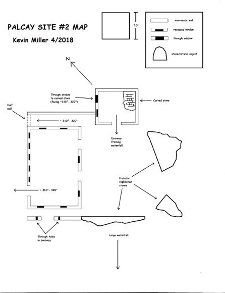
Although well off the tourist circuit, I had expected to see Palcay cleared and at least partially restored and protected. It appeared as if it had not been touched since our last visit. Walls were crumbling, cattle had been inside the structures, vines, moss and shrubs had reclaimed much of what we previously had documented.
The only sign of official activity was a small cement monument with a brass plate stating that “this is a protected archaeological site in the Machu Picchu Park.” Protected by whom and how we wondered?
However some changes had happened. An elderly lady who Hugh Thomson had mentioned meeting there many years back greeted us upon arrival. She asked for payment and complained that we had damaged the trail down from the pass. She said that she planned to put up a locked gate on the pass to prevent such intrusion.
After lengthy dialog in Quechua and the exchange of several hundred Soles, Peru’s currency, the problem was resolved. We were free to camp and conduct our investigations.
Yet another surprise awaited us. “Jefe, hay un Gringo viviendo aqui.” (Boss, there is a foreigner living here). Soon, an amiable American from upstate New York arrived at our camp, introducing himself as Nate.
He had been living here for sometime involved with various studies and projects which we did not probe into.
An Item that caught my immediate attention was the mention of more ruins on the other side of the Aobamba river including a stone monument with incised petroglyphs which Nate had found. Unfortunately, we were short on time, scheduled to move out the next morning for the long slog up to the investigation of our primary objective, the ridge top sites far distant above.
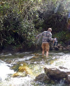 Kevin immediately volunteered to accompany Nate across the somewhat intimidating swift torrent for a quick recon of what might be there. The next morning, I briefed on collecting details, loaned him my Brunton surveying compass and off they went while we packed camp.
Apparently, there is a ceremonial aspect to Palcay which we had suspected but failed to find in 2006.
Nate and Kevin’s quick probe seems to substantiate this. I regretted our schedule could not permit another day here. Anyway, we now have a solid reason to return.
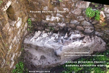
Meanwhile, Kevin returned with several photos and a description of what we will call Palcay, Sector II.
 Leaving Palcay behind and as it turned out, the last comfortable camp, a good trail continues across the big side canyon coming down from Salcantay to a small potato farm and Nate’s new cabin where it abruptly ends.
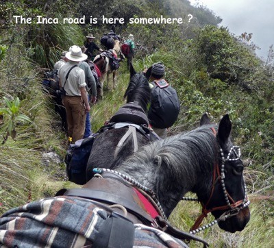
Climbing steeply upward, the overgrown remnant of an old Inca trail heads diagonally up. We expected tough going but nothing like what we now encountered. We had hiked down a part of this in 2006 with backpacks, not with a string of saddle horses and pack mules. We took turns up front swinging machetes while slogging through deep mud. Edwin reassuringly says “guys it will go – we did this last year on the recon – not to worry.”
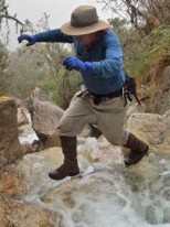
Despite Edwin’s assurance, we did have growing concern. An ominous start was crossing a swiftly flowing stream of knee deep, cold water which filled boots.
The soles of my super tech, ‘waterproof,’ new age boots were already coming apart, secured by duct tape.
 As light rain and fog settled in for the remaining days of the expedition, the boots never dried along with all the other water- logged gear. Fortunately, sleeping gear and spare clothes stayed dry in bags on the pack mules. It was during the next several days travel that Steve’s wreck and several others occurred, fortunately all without injury.
The route we had taken in around Salkantay from the southeast was mostly dry, well engineered by the Inca builders with switchbacks and occasional stone steps, placed well above bogs. It is kept open and somewhat in repair by the several families living in the upper Aobamba valley who use it for access out to the modern roads.
This main Inca road from Palcay originally continued down the Aobamba connecting to the route to Machu Picchu from Llactapata. We followed this to the railroad terminal and hydroelectric plant below in the Urubamba Canyon in 2006.
It was difficult to travel with massive washouts and passible only by foot. Apparently, there has been no interest in reopening it. The high boggy, cloud forest trail we are now climbing is certainly not in use by anyone.
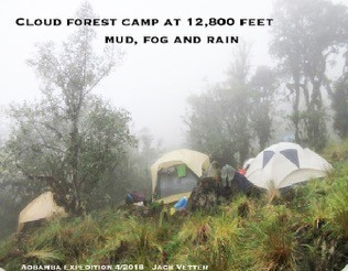
During a lunch break, Pio has managed to get the pack string around us and out in front. Late in the day, we stumble exhausted, soaked, caked in mud, into a high grassy basin with tents up and waiting.
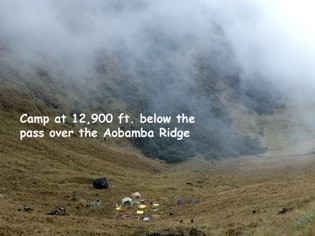 Pio’s wanglers have accomplished the impossible, struggled all day with the animals, mud, packing, unpacking and still managing to have camp set up for our arrival. They are the best! Steve’s GPS says we are at 12,900 feet.
I pull my large, yellow river bag into the tent and zip up the door. A plastic tarp is inside to keep items dry from the floor which always bleeds moisture up from the ground. We have long
used inflatable, waterproof, sleeping pads so unless something touches the side of the tent items that arrive dry, stay dry.
Changing into warm fleece, I toss the mud covered, soggy boots outside in the rain. Maybe it will wash off the mud? Pulling on a pair of neoprene dive boots, I slosh over to the big dinning tent.
Bill and Jack are already at the table munching quesadillas and popcorn . All arrive. Edwin appears with a bottle of Johnny Walker Black to complement the hot tea and rapidly disappearing snacks.
It is amazing how fast we all come back to life, hardships forgotten with a good dose of comforts and conversation. Talk winds down when plates heaped with fried chicken and mashed potatoes arrive. It is soon back to individual tents hopefully, for a long night’s comfortable sleep.
Tomorrow’s exploration is the targeted prime objective. What is up there beckoning in the clouds; the Lost City of Z, maybe legendary Paititi? My altitude-disturbed dream lapses into vivid, pure fantasy.
We already know there are walls and at least a mirador or ceremonial platform on the ridge top or we would not have planned the expedition here. We found small sites in 2006. Johan Reinhard had documented two interesting sites on the ridge lower down and closer to the extensive Llactapata complex. We are certain more worth investigating are to be found up there.
Michihuayunca; place of the dead cat
As first light illuminates the tent, the sound of steady, light rain on the fly disperses any hope for a sunny, clear day. Whew, here we go again. We organize over ample servings of eggs, bacon and coffee. The order of march is established.
Bill and Jack elect to stay in camp, recovering from the long slog. Steve, Edwin and Kevin accompanied by most of the staff will climb the cliffs to find and survey whatever is up there. George and I plan a climb up to the pass, abra to document the site there.
Happy hour is indeed happy tonight! Edwin produces a bottle of Peruvian made, Russian vodka from the kitchen supplies, carried carefully along by a selected mule we call, of course, ‘The Booze Burro’.
Evening cordials in moderation before dinner has been an expedition tradition going way back.
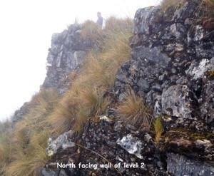
A round of toasts launches spirited (no pun?) accounts of the day’s explorations. The exhilarated summit team describes an unusual ridge top complex. Getting there was close to some of the serious mountaineering we had done in the past, requiring roped belays across several steep, slick sections.
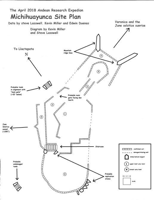
The main structure is a multi-tiered, large, earth- filled, stone-walled construction some one hundred seventy by seventy feet in size, shaped in a bent oval, something like text book images of a paramecium with walls following the curving contour line of the hill top.
 The vertical height is about thirty feet.
The team had a difficult time photographing and measuring through the deep Ichu grass and brush cover but believe that they have it correct. There must have been a major Inca walkway to get there from Llactapata but they could not find it. Johan Reinhard says he found a section of Inca road lower down during his 1985 exploration.
There are likely other sites along the ridge but all is overgrown and travel is near impossible. Without ethnohistorical reference to identify the site, we will never know what the Inca name may have been. We decide to call it, Michihuayunca, the local name for the region.
 The primary alignment is north toward Machu Picchu-Llactapata with other walls facing or pointing toward the June solstice and surrounding Apus, Inca sacred mountains; Veronica, Waqay Willca, and the Puma’s Claw, Pumasillo.
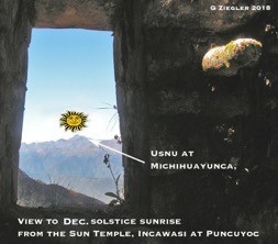
The important ceremonial site, Inca Wasi in the Puncuyoc range above and north of the Neo-Inca Vilcabamba capital, Vitcos, thirty miles distant, is on the June solstice sunset line. From a building there which we identified as a sun temple in 1998, the sightline view would see the sun raising over the Aobamba ridge during the December solstice.
A worked-stone entrance-way and stone stairs give access up through the several walls and levels:
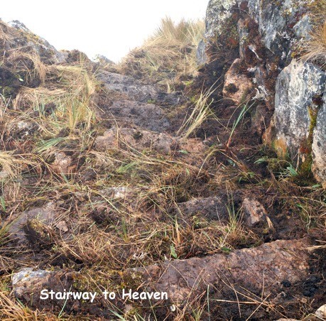
Recalling an old Led Zeppelin song, I suggest with a grin that it may be a ‘Stairway to Heaven,’ Kim Malville’s symbolic pathway to the Inca upper world, Hanan Pacha.
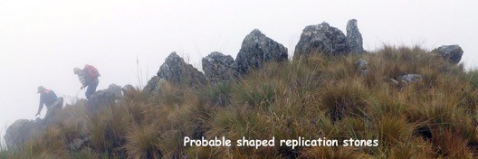 Like most Inca sites with a ceremonial function, a number of sculptured boulders were placed about probably replicating distant mountains.
With fog and cloud shrouding the region it was impossible to verify. Only one good, brief view of Huayna Picchu was had when the clouds momentarily parted.

Two interesting outlying features may be burial tombs. One has been looted and the other is intact. We have yet to find a sizable site that does not show evidence of some previous destruction from treasure hunters, huaqueros. During the five hundred or so years after the Inca left, generations of prospectors, herders and and others have been almost everywhere in the remote Andes. Machu Picchu apparently had been looted long before Hiram Bingham got there.
After initial clearing at Llactapata, we returned the following year to discover in horror that a special, small granite shrine in Sector III had been completely destroyed by looters. Fortunately, we had photos and the previously surveyed plan. It was doubly tragic in that this was the only structure there built with imported Machu Picchu granite.
It is ironic for looters that the Inca left very little of value behind or in burials. The gold-encased mummies the world knows mostly came from the Moche and earlier costal cultures. At most, they might have found a broken pot or copper shaw pin for their effort.
Anyway, This unique, high altitude structure, or more properly, archaeological group at 14,160 feet appears a significant find.
With breathtaking 360 degree view of a most sacred Inca landscape radiating around Inca Pachacuti’s ceremonial centerpiece, Machu Picchu, it is an important component of the Machu Picchu-Llactapata ceremonial neighborhood.
Abra Usnu; The Usnu at the Pass
While the exploration proceeded above, George and I documented a smaller, less complex site at the top of the pass. We had noticed the walls in 2006 but had not taken the time to properly examine them.
It is a nicely made, two-level platform with an extending, walled plaza. The walls are constructed from an aesthetically pleasing, black and white speckled, igneous gabbro. The Inca trail passes through with stone steps at each end. The structure is situated at the high point of the trail with
masonry completely filling the narrow gap of the natural topography.
It must have been significant to the builders that the trail-facing walls and steps align perfectly with the December solstice sunset.
It would have been a resting place to give thanks to the spirits of the mountains, apus, for safe passage when crossing over the pass. Small offerings and stones carried up, apachitas, would have been carefully placed on the platform.
We have seen many of these platforms near high Inca trails throughout the Vilcabamba range. We called them miradors or sacred platforms over the years but they are better described as an usnu. The term refers to constructed platforms around the Andes use for various ceremonial proposes and events. In the Vilcabamba, they range in size from a few feet to large, truncated hill tops at Cerro San Miguel, near Machu Picchu and the big Usnu at Choquequirao measuring almost two hundred feet across.
American explorer-architect Vince Lee has identified a series of such platforms which are inter-connected in view from Choquequirao to Machu Picchu. He suggests that they may have been used as a system for relaying simple messages.
The next morning’s continuing rain gets us off to a slow start. Packing up the rested and well fed mules and horses, we slog slowly up and over the pass for what we hope is an easy downhill day. It is not in the cards.
Several attempt to ride but the terrain again proves too dangerous. Onward we go on foot. To our dismay the route stays high and continuously boggy with numerous, steep, ups and downs.
We are starting to look like a scene from “Bridge at the River Kwai”
I whistle a stanza of the ‘Colonel Bogey March’ to multiple groans and grimaces.
 Finally, late in the afternoon, a campsite is found at one of the few possible places, a down sloping, muddy clearing in dripping, cloud forest tangle at 12,100 feet. During earlier climbing years, we would have called it a bivouac.
YES – there is one bottle of Johnny Walker left in the dwindling supply stash! Cups are passed around giving a warming cheer to the dreary camp situation. Amazingly, Pancho and his assistant Humberto manage to serve up another near-gourmet dinner. Rain and sloping tents be damned, we’ll sleep tonight. Tomorrow will be an easy down hill run to the Santa Teresa Valley road with transport to comfort and dry luxury at Pio’s daughter’s deluxe, boutique lodge!
The final day arrives. As one might predict, it is more of the same; up, down, mud, rocks, too dangerous to ride. Fortunately, the crew of locals hired to clear the trail down for us had been working from below for several days making it just passable for the animals.
The Huaca Site at 12,185 feet
The highlight of the descent was coming upon a small, open basin with a collection of boulders that appeared to be shaped and placed amphitheater-like in a now filled in pond. As eager as we were to continue, this demanded attention.
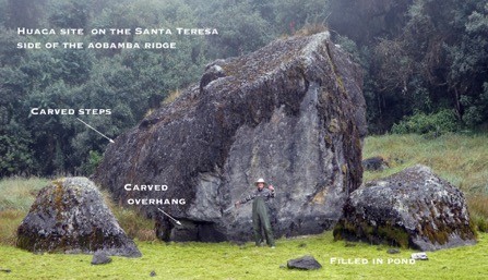
The mist cleared just enough for a few photos. We gave it enough time to reveal typical huaca cut steps and an undercut cave feature on the largest rock. The place has the feel and features of a special, sacred site similar to Quillarumiyoc and the White Rock, Yuroc Rumi at Vitcos.
Importantly, the site is now GPS located. Someone should go back. Whew, will we be up for this route again?
So the story ends. We arrive without incident to warm, lowland Santa Teresa, a mere 5,000 feet something in altitude. After a night indulging in luxurious, lodge comfort, we enjoy the relaxed, now not so long, drive back to Cusco on improved new highway.
Of course – we will return. The Lost City of Z is still up there!
Observations and Conclusions
Palcay
From the investigation and survey in 2006, we concluded that the site’s primary function was that of a tambo way station on the Inca road. The road was an important route connecting the major, high Inca road, Cápac Ñan from Cusco to Choquequirao and the Vilcabamba with Machu Picchu.
Palcay probably also served as a regional administrative station for the upper Aobamba valley which would have involved cultivation of potatoes and other crops, perhaps the raising of llamas and road maintenance.
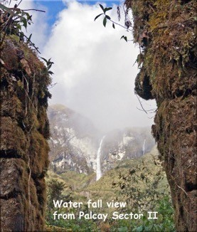
The setting is spectacular, located at the confluence of two deep canyons with a long waterfall plunging from the glaciers of Salkantay as a backdrop. Although, the site may have been primarily utilitarian in function, the association with this sacred geography would have required a ceremonial aspect as well.
We were surprised that we did not find it. Now it appears we have. The several structures visible are of careful construction with alignment and view toward the waterfall incorporating shaped huaca stones in the design. It will be exciting to see where the new sector fits when cleared and studied.
Michihuayunca
This complexly designed structure of multiple walls, levels and focused overlooks fits with other regional sites in view of and associated with Machu Picchu as the hub of a ceremonial neighborhood. The high altitude, bleak conditions and difficult trail up the ridge from Llactapata suggests that it would have been used only during special rituals and celebratory dates, perhaps by special religious orders or for an elite pilgrimage.
A small, enclosed compound of two buildings previously documented by Johan Reinhard several thounsand feet lower on the ridge, may have served as a residence for attendants and occasional overnight lodging.
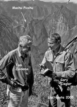
 Kim Malville and I have suggested that Machu Picchu may have hosted a Ceques system of imaginary lines radiating outward to a network of surrounding spiritually important places and objects. Ethnohistorian Tom Zuidema wrote that every important Inca settlement had one.
“Zuidema, R. Tom.1964. The Ceque System of Cuzco: The Social Organization of the Capital of the Inca. E. J. Brill, Leiden.”
Zuidema suggested that ceques might have been sight lines to sacred mountains and astronomical phenomena as well as geometrical partitions that organized the sacred landscape. Over the years we have located and studied many features, regional sites, shrines and buildings that have geographical, astronomical, or cosmological meaning associated with Machu Picchu, most importantly, the Llactapata complex.
 The Michihuayunca Usnu fits well with this concept. The 360 degree view, size, location and designed alignments would have great importance in the Inca – Machu Picchu sacred geo-cosmic universe.
As Bob Dylan said “ I don’t know but I‘ve been told, the streets of Heaven are lined with gold,” Maybe Pachacuti sent some up on Michihuayunca’s celestial stairway?
Acknowledgements and credits
A huge thanks goes to all the team members for making the exploration a success in spite of adverse weather and dangerous conditions at high altitude. It required a tremendous effort to gather data and photographically document the sites in fog and rain.
The result is several excellent site plans and a large selection of quality images to support the descriptions in the report. Diagrams are individually credited. Photos are collectively credited to all.
Regional Map and Diagram
__________________________________
✐ Gary Ziegler is a field archaeologist with a geology background, mountaineer and explorer who has spent a lifetime finding and studying remote Inca sites in the Vilcabamba range of Peru’s Southern Andes. He is a Fellow of the Royal Geographical Society and of the Explorers Club. He has featured in documentary films for the BBC, Discovery Channel, Science and History Channels.
In 2013, he was awarded the title “Distinguished Lecturer” at NASA’s Marshal Space Center. He has taught at Colorado College and Peru’s national university, San Marcos. His home base is 4000 acre Bear Basin Ranch in the Sangre de Cristo Mountains of Southern Colorado’s Custer County where he is former County Sheriff and a founder of the search and rescue unit.
Join Gary and his team on their next Andean exploration adventure or narrated horse and hiking trip from their Cusco ranch.
Custom designed programs for two or more to suit your dates and desires:
Email: info @ adventurespecialists.org
US phone: 1-719 -783-2076
Web: adventurespecialists.org
Bibliography
Brian S. Bauer, Javier Fonseca Santa Cruz, and Miriam Aráoz Silva (2015). VIilcabamba and the Archaeology of Inca Resistance. University of New Mexico Press
Brian S. Bauer, Madeleine Halac-Higashimori, and Gabriel E. Cantarutti
(2016).Voices from Vilcabamba. University of Colorado Press.Bingham, Hiram, (1952) Lost City of the Incas. Phoenix House, London
(revised edition).
D’Altroy, Terence. (2003). The Incas. Blackwell Publishing, London. Hemming, John. (1970). The Conquest of the Incas. Revised edition,1993.
Pan-Macmillan, London.
Hyslop, John. (1984). The Inca Road System. Academic Press, New York. Lee, Vincent, (2000). Forgotten Vilcabamba: Final Stronghold of the Inca.
Empire Publishing.MacQuarrie, Kim. (2007). The Last Days of the Inca. Simon & Schuster, NY.
Reinhard, Johan. (1990). ‘Informe sobre una sección del camino Inca y las ruinas en la crestaque baja del nevado de Tucarhuay entre los ríos Aobamba y Santa Teresa’ Revista Sacsahuaman, no. 3:163-187, Cusco.
(2007). Machu Picchu: Exploring an Ancient Sacred Center, 4th edn. Cotsen Institute of Archaeology, Los Angeles.
Savoy, Gene. (1970). Antisuyo, The Search for the Lost Cities of the
Amazon. Simon andSchuster, N.Y.Titu Cusi Yupanqui. (1570). Relacion de la Conquista del Peru y Hechos del Inca Manco II.
Thomson, Hugh. (2001) The White Rock’ An exploration of the Inca
Heartland, Orion, London
(2006). A Sacred Landscape – The search for Ancient Peru, Overlook, NY. Ziegler, Gary. (1999). Vilcabamba, Report from the Field. South American
Explorer. vol 57.(2015) Beyond Machu Picchu; Choquequirao, Lost City in the Clouds. Peruvian Times, Lima. https://www.peruviantimes.com/06/beyond-machu- picchu-choquequirao-lost-city-in-the-clouds/23519/
(2015) Choquequirao Field Report, Peruvian Times. Lima https://www.peruviantimes.com/18/choquequirao-field-report-2015/25121/
(2017) The Road to Ruins, Report of the 2016 Andean Research Project. Peruvian Times, Lima;
Ziegler, Gary and J Mckim Malville (2013). Machu Picchu’s Sacred Sisters; Choquequirao and Llactapata; Astronomy, Symbolism and Sacred Geography in the Inca Heartland. Johnson Publishing, Boulder.


Having lived in Arequipa,Peru, in 1962-64 as a Peace Corps Volunteer, United States of America, I always have an itense interest in exploratory activities in beloved Peeru. This extensive description adds to my knowledge. A thank you to all involved in this expecition as well as to future exploratory parties who will continue uncovering the once hidden history of Incan Peru.
Hello Patt
Thanks for your interest and support in continuing explorations.
I wonder if we may have met? I was on the Peace Corps training staff at Camp Radley
in Puerto Rico in 1962. We probable trained your Peru group.
Gary Ziegler
So well written an detailed, it made me feel as if I were there every step of the way
Dear Gary:
I use to spend my vacations when i was a kid in Aguas Calientes (Machupicchu), and i remember very much the trains, specially the old steam locomotives, i wonder if you have more pictures about them, in Machupicchu or maybe in Quillabamba.
Thanks and best regards
Miguel
Hola Gary: Last November we’ve hiked from Choquequirao to Yanama with David Espejo, he is an old good friend, just want it to let you know he is back in his adventures with the same energy as always. Actually we are taking a group of friends next abril from Totora to Huancacalle and finish at Espiritupampa. take care and good travels Amigo